


Our drone-powered services include:
-
Aerial photography and videography for inspections and construction documentation
-
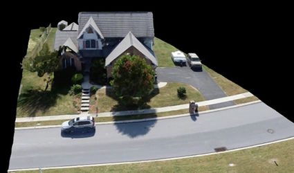
Data collection and processing for 3D scanning to support structural construction, preservation, and planning
-
Thermal imaging and LiDAR mapping services
-
sUAS (drone) programs for grade-level and college-level students.
“With a project site that was difficult to access and navigate, SkyPixGroup’s drone photography allowed contractors and consultants readily available photographs that eliminated some of the potential challenges of getting through the overgrown forest.”
– Tanya Dierolf
Sustainability & Strategic Projects Manager
Capital Region Water
Professional Capabilities:
-
Inspections
-
3D Mapping
-
Construction Project Progression
-
Training and Deployment Support


Credentials:
-
FAA Certified Pilots
-
OSHA 30 Certified
-
FEMA Certified
-
Thermography Certified

Our Fleet:
-
EBEE M300 RTK Phantom 4 Pro
-
Anafi Thermal Quantum Systems Trinity
NAICS Codes:
541370 | 541922 | 51820 | 488490 | 926130
“SkyPixGroup did an outstanding job hosting and facilitating our FIRST drone summer camp for high school students. Their knowledge and experience provided excellent background to deliver a quality learning experience for our students, and exposed them to careers in the 127 Billion dollar industry!”
– S. Keith Hargrove
Former Dean, College of Engineering
Professor, Mechanical Engineering & Manufacturing
Engineering Department
Tennessee State University


Our FAA certified drone pilots are fully insured and present a hands on experience that introduces students to the following:

And More!
-
UAS safety – FAA compliance
-
FAA Part 107 license overview
-
Basic drone components
-
Risk Mitigation
-
GIS applications
-
Industry speakers
-
Intro to – Geospatial 2D & 3D mapping, Inspections & UTM outlook
*Geospatial technology involves GPS (global positioning systems), GIS (geographical information systems), and RS (remote sensing). This technology enables production and use of maps required to manage our communities and industries.
Get the full drone experience.
SkyPixGroup helped local students tap into their science and engineering skills in a pre-college program at Tennessee State University to learn how to build and fly drones.
Email: info@skypixgroup.com
LinkedIn: linkedin.com/in/wendy-jackson-dowe/